5 Day itinerary in Colombia, South America
Los Nevados Traverse
"Los Nevados" refers to Santa Isabel, El Ruiz and El Tolima, volcanoes that are each over 4900 meters (16,076 feet) high and perennially covered in snow and ice. This national park is remarkable not only for having glaciated mountains in the tropics but also for its variety of ecosystems and rich bi... Read More

By Leo and Cami
Overview
Physical Difficulty
Demanding
Recommended Age
Everyone
Operated in
English, Spanish
GUIDANCE
Tour Guide
starting point
Pereira
trip type
Private
trip attributes
Hiking
Meet local people
Rural home stays
Nature & Wildlife
Culture & Heritage
 Start
Start
 Night
Night
 End
End
Highlights
Use mountaineering techniques to climb up Nevado de Santa Isabel (no previous experience required)
Trek through a páramo, a unique environment of glacial lakes and succulent plants.
Hike through a cloud forest full of exotic birds and flowers.
Sleep in quaint mountain farmhouses and get a taste of Andean farm life.
Itinerary
Accommodation Categories
Day 1
Travel through the Coffee Region
Your adventure starts at the Pereira airport where you meet your guide. Together you drive on scenic mountain roads through the Coffee Region, passing small towns, coffee plantations and farmlands. After an enjoyable drive through the countryside you arrive in El Cisne, a mountain lodge high up within the Los Nevados National Park. You spend the rest of the day taking a walk around the surrounding area and enjoying the high Andean environment.
After dinner your guide gives you a briefing for the big day ahead and you go to bed early for tomorrow's alpine start.
Meals: Lunch, Dinner
Day 2
Climbing Santa Isabel Volcano
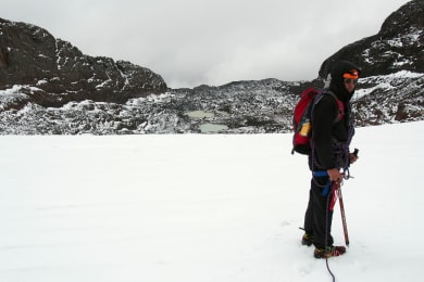
The day begins with breakfast at 2:30AM then you drive to the Nevado de Santa Isabel trailhead at 4000 meters (13,123 feet). The trail ascends immediately and you hike by headlamp light through a highland forest of dwarfed trees, mossy plants and small lagoons. As dawn breaks so does the dense vegetation and you get open views of rock cliffs and mountainsides. Patches of snow appear as you go higher, accentuating the barren but beautiful landscape with white. A collection of glacial lakes sit just below the Santa Isabel glacier and soon after passing them you break out the helmets, harnesses, rope and crampons. The final push up the glacier which starts at 4700 meters (15,420 feet) is the most exciting and most difficult part of the ascent. Your stamina, determination and the weather determine how high you go. The high point is at 4,950 meters (16,240 feet), just a few meters below the true summit which is guarded by a sheer rock wall. If you make it that far you've ascended 950 meters (3117 feet) in 4.5 kilometers (2.8 miles). Congratulations, you've climbed one of the three famous Nevados. Now you need to get back down.
8 to 9 hours after starting you arrive back at the trailhead. Hot food and well deserved rest await you at El Cisne.
Meals: Breakfast, Lunch, Dinner
Day 3
Otun Lake and the Paramo
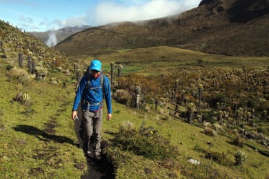
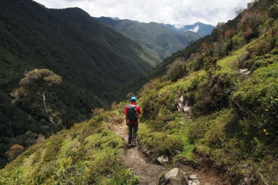
Today you start making your way south across Los Nevados National Park. You trek from Campoalegre and follow a wide mountainside trail with sweeping views of meadows and hills full of wild flowers. From the trail you see El Ruiz, the infamous and highly active volcano that killed 25,000 people when it erupted in 1985. After an hour or so you reach Laguna de Otun, a lake fed by the Santa Isabel glacier that you hiked yesterday. The lake sits at 3900 meters (12,795 feet) above sea level and is the source of the Otun River that supplies drinking water to the city of Pereira where you started this adventure. After enjoying the view of the lake and the waterfalls that feed it you leave the wide mountainside trail and follow a narrow path that takes you through a garden of exotic succulent plants. This is the beginning of your trek through the páramo. Your hike takes you across streams, along a mountain ridge, and down a valley. At one point you go through a natural tunnel created by the interlaced branches of gnarled siete cueros (seven skins) trees.
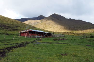
The toughest part of the day's hike comes near the end as you ascend a steep gully up a mountain before going down to the valley of Berlin where you spend the night at the farmhouse of your host family. The Berlin farm, at 3840 meters (12,598 feet), is picture perfect with its surrounding cliffs, stream, boulder-dotted fields and grazing farm animals. With another 13 kilometers (8 miles) under your belt you spend the evening gathered around a firewood stove relaxing and chatting with your hosts Diego and Maria.
Meals: Breakfast, Lunch, Dinner
Day 4
Tolima Volcano and the Cloud Forest
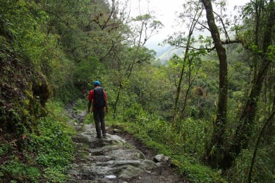
Today starts with a challenging ascent to the border of the Risaralda and Quindio departments. At 4300 meters (14,108 feet) this is the highest point of your trek outside of Nevado de Santa Isabel and from here you can see Nevado del Tolima. The rest of the day is a gradual descent and you leave the páramo to enter the cloud forest. At higher altitude the forest is less dense and the mountainside trail that you follow still affords open views of dark green valleys and rocky cliffs. In early afternoon you arrive at the Argentina farm at 3540 meters (11,614 feet). After lunch you hike to a waterfall. At this lower elevation the cloud forest is as rich as a rainforest and countless exotic birds and flowers bombard your senses with color and sound. After another 10 kilometer (6 mile) day you spend the night back at the Argentina farmhouse where you rack your brain trying to solve Don Javier's highly frustrating puzzle.
Meals: Breakfast, Lunch, Dinner
Day 5
The Wax Palm Forest and Cocora Valley
As you descend to the lowest part of the cloud forest the tallest trees emerge. The wax palms shoot 60 meters (200 feet) straight into air and loom over the surrounding fog and dense foliage. Orchids and bromeliads are also prevalent in this part of the forest. Your hike takes you across streams and over log bridges. As you near the end of your trek you enter the famous Cocora Valley where farmers have cleared the forest but left the wax palms standing, creating a dramatic landscape of tall trees standing in sharp contrast to grassy hills.
Your trek ends at a restaurant in Cocora Valley at 2300 meters (7546 feet) where you reward yourself with a well-deserved lunch (the specialty is rainbow trout and patacon). Today's 10 kilometers (6 miles) brings your total to 41 kilometers (25.5 miles). You've had the complete Los Nevados experience and can go home with a full camera and a full heart.
After lunch you visit the quaint town of Salento before driving to the Pereira airport.
Meals: Breakfast, Lunch
What’s Included
Meals
- Lunch (5)
- Dinner (4)
- Breakfast (4)
Transport
- Private land transportation starting and ending at the Pereira airport
Activities
- All entrance fees
About Leo
TEAM LEAD
+1 Local experts
Baboo Certified
5 (15 reviews)
Hiking
Snorkeling/Diving
Visit markets
Meet local people
Rural home stays
Indigenous culture
Culture & History
Kayak & Canoe
Water & Coastline
Nature & Wildlife
Culture & Heritage
I grew up in the Philippines, studied in the US and worked in Colombia. Now I live in the US with my Colombian wife. I love adventure sports and traveling to experience natural wonders. Arranging trips for others is my way of sharing my passion.
Travel that Makes a Difference
By choosing to travel with us, you support local communities, wildlife, and the environment. We are dedicated to positively impacting the world through every journey we offer.


Let’s regenerate the planet together
We overcompensate your entire journey’s carbon footprint including flights - for free.
$1,400.00 USD